About Our Country
Myanmar,officially the Republic of the Union of Myanmar, and also known as Burma, is a country in Southeast Asia. Myanmar is bordered by India and Bangladesh to its west, Thailand and Laos to its east and China to its north and northeast. Myanmar is the largest of the mainland Southeast Asian states. As of 2017, the population is about 54 million.Myanmar is 676,578 square kilometres (261,228 square miles) in size. Its capital city is Naypyidaw (Nay Pyi Taw), and its largest city is Yangon (Rangoon). Myanmar has been a member of the Association of Southeast Asian Nations (ASEAN) since 1997. Myanmar is a member of the East Asia Summit, Non-Aligned Movement, ASEAN and BIMSTEC, but not a member of the Commonwealth of Nations. It is a country rich in jade and gems, oil, natural gas and other mineral resources. Myanmar is also endowed with renewable energy; it has the highest solar power potential compared to other countries of the Great Mekong Subregion. In 1989, the military government officially changed the English translations of many names dating back to Burma's colonial period or earlier, including that of the country itself: Burma became Myanmar. The renaming remains a contested issue. Many political and ethnic opposition groups and countries continue to use Burmabecause they do not recognise the legitimacy of the ruling military government or its authority to rename the country.
Geography of Myanmar
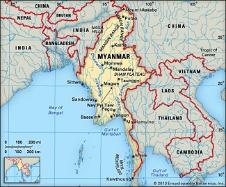
Myanmar has a total area of 678,500 square kilometres (262,000 sq mi). It lies between latitudes 9° and 29°N, and longitudes 92° and 102°E. As of February 2011, Myanmar consisted of 14 states and regions, 67 districts, 330 townships, 64 sub-townships, 377 towns, 2,914 Wards, 14,220 village tracts and 68,290 villages. Myanmar is bordered in the northwest by the Chittagong Division of Bangladesh and the Mizoram, Manipur, Nagaland and Arunachal Pradesh states of India. Its north and northeast border is with the Tibet Autonomous Region and Yunnan for a Sino-Myanmar border total of 2,185 km (1,358 mi). It is bounded by Laos and Thailandto the southeast. Myanmar has 1,930 km (1,200 mi) of contiguous coastline along the Bay of Bengal and Andaman Sea to the southwest and the south, which forms one quarter of its total perimeter. In the north, the Hengduan Mountains form the border with China. Hkakabo Razi, located in Kachin State, at an elevation of 5,881 metres (19,295 ft), is the highest point in Myanmar.[116] Many mountain ranges, such as the Rakhine Yoma, the Bago Yoma, the Shan Hills and the Tenasserim Hills exist within Myanmar, all of which run north-to-south from the Himalayas. The mountain chains divide Myanmar's three river systems, which are the Irrawaddy, Salween (Thanlwin), and the Sittaung rivers.[118] The Irrawaddy River, Myanmar's longest river, nearly 2,170 kilometres (1,348 mi) long, flows into the Gulf of Martaban. Fertile plains exist in the valleys between the mountain chains.[117] The majority of Myanmar's population lives in the Irrawaddy valley, which is situated between the Rakhine Yoma and the Shan Plateau.
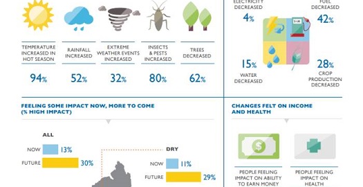
Climate
Much of the country lies between the Tropic of Cancer and the Equator. It lies in the monsoon region of Asia, with its coastal regions receiving over 5,000 mm (196.9 in) of rain annually. Annual rainfall in the delta region is approximately 2,500 mm (98.4 in), while average annual rainfall in the Dry Zone in central Myanmar is less than 1,000 mm (39.4 in). The Northern regions of Myanmar are the coolest, with average temperatures of 21 °C (70 °F). Coastal and delta regions have an average maximum temperature of 32 °C (89.6 °F).
Languages
Burmese, the mother tongue of the Bamar and official language of Myanmar, is related to Tibetan and Chinese.[309] It is written in a script consisting of circular and semi-circular letters, which were adapted from the Mon script, which in turn was developed from a southern Indian script in the 5th century. The earliest known inscriptions in the Burmese script date from the 11th century. It is also used to write Pali, the sacred language of Theravada Buddhism, as well as several ethnic minority languages, including Shan, several Karen dialects, and Kayah (Karenni), with the addition of specialised characters and diacritics for each language.
Religions
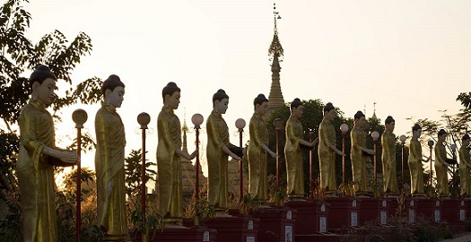
A large majority of the population practices Buddhism; estimates range from 80%[319] to 89%.[320] According to 2014 Myanmar Census, 87.9% of the population identifies as Buddhists.[312] Theravāda Buddhism is the most widespread.[320] Other religions are practised largely without obstruction.
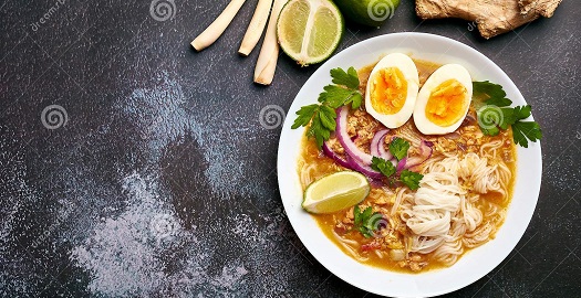
Cuisine
Burmese cuisine is characterised by extensive use of fish products such as fish sauce, ngapi (fermented seafood) and dried prawn. Mohinga is the traditional breakfast dish and is Myanmar's national dish. Seafood is a common ingredient in coastal cities such as Sittwe, Kyaukpyu, Mawlamyaing (formerly Moulmein), Mergui (Myeik) and Dawei, while meat and poultry are more commonly used in landlocked cities like Mandalay. Freshwater fish and shrimp have been incorporated into inland cooking as a primary source of protein and are used in a variety of ways, fresh, salted whole or filleted, salted and dried, made into a salty paste, or fermented sour and pressed. Burmese cuisine also includes a variety of salads (a thoke), centred on one major ingredient, ranging from starches like rice, wheat and rice noodles, glass noodles and vermicelli, to potato, ginger, tomato, kaffir lime, long bean, lahpet (pickled tea leaves), and ngapi (fish paste).
Attractions
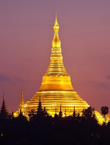
One of Buddhism's most sacred sites, the 326ft zedi (stupa) here is adorned with 27 metric tons of gold leaf, along with thousands of diamonds and other gems, and is believed to enshrine strands of the Gautama Buddha's hair as well as relics of three former buddhas. Four entrance stairways lead to the main terrace. Visit at dawn if you want tranquillity; otherwise, pay your respects when the golden stupa flames crimson and burnt orange in the setting sun.
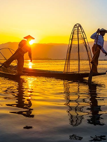
Inle Lake is on many wish lists of places to visit in Myanmar and for good reason: vast and serene, the lake is large enough for everyone to come away with their own, unique experience of life here. If you’re counting days, hit the hot spots: the temples, markets and floating gardens. With more time, you can explore the remote corners of the lake, visit the fishing villages around it, or hike in the nearby hills. Whatever you do, the memories of gliding across Inle’s placid waters will stay with you forever.
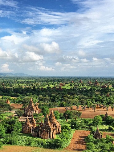
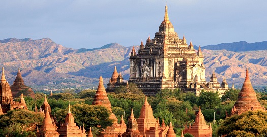
Awarded World Heritage status in 2019, the 3000-plus temples scattered across the plains of Bagan are amazing to behold. Most of the 11th- to 13th-century vintage temples have been renovated, as Bagan is an active religious site and place of pilgrimage. Yes, there are tour buses and crowds at the top sunset-viewing spots, but they can be avoided. Pedal off on a bike and have your own adventure amid the not-so-ruined temples, or float over the incredible scene in a hot-air balloon.
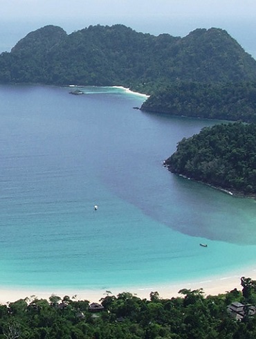
About 800 barely populated islands, many with white-sand beaches sitting in a turquoise sea, some of the best diving in the region, roving 'sea gypsies' and barely a tourist to be seen: it’s hard to believe that a place like the Myeik Archipelago still exists in Southeast Asia. Accessing these gorgeous islands takes time and is not cheap; accommodation is either aboard a boat or at one of just four upmarket resorts. Make the investment and you will get to live out every beach junkie’s fantasy.
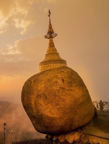
A crowded, windy and potentially nausea-inducing ride up a remote hill to look at a big gilded rock might not sound like a country highlight. But this is no ordinary boulder. Mt Kyaiktiyo is the location of Myanmar's most important religious pilgrimage after Shwedagon Paya. This is a chance to witness a uniquely Myanmar-style of spiritualism as pilgrims chant and light candles through the night. Visit at dawn or dusk to see the gold-leaf-covered rock at its most magnificent.
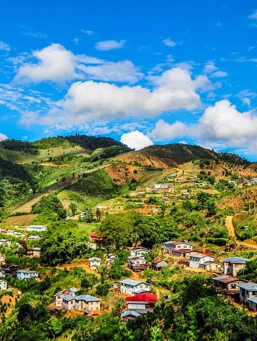
With cooler temperatures, higher elevations and many locals descended from Nepali Gurkha soldiers, Kalawboasts an almost Himalayan atmosphere. Unsurprisingly, this is one of the best places in Myanmar for upcountry treks, with the authorities relaxed about foreign visitors getting off the beaten track. As you hike through the Danu, Pa-O and Taung Yo villages that dot the forests, fields, trails and roads linking Kalaw with Inle Lake, you’ll get a real insight into the lives of the hill peoples who populate the area.
© 2024 PSH Trading Co.,Ltd. All rights reserved | Design by Myanmar Web Designer